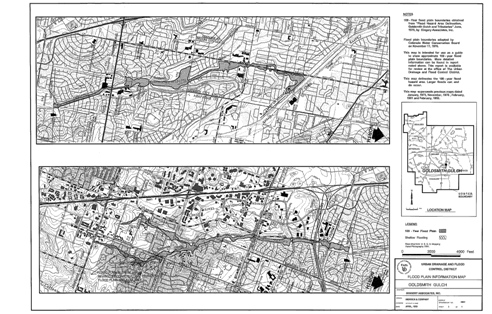
Web-based Floodplain Mapping an Inaugural SuccessBy Bruce Rindahl, Leonard Rice Engineers Each year UDFCD sends approximately 24,000 flyers to addresses within the District that are located in or near identified flood hazard areas. In the past these flyers included maps prepared by manually transposing 100-year floodplain delineations from the original studies onto USGS topographic maps. The map scales were typically 1:24000 and were quite outdated in fast growing sections of the District. Sixty-seven hazard-specific flyers were produced, one for each major drainageway in the District. Figure 1 shows an example of a typical flood hazard information map used prior to 2006.
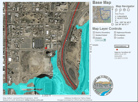
In 2004, the District began developing web-based applications for flood warning and floodplain displays using Scalable Vector Graphics (SVG). SVG allows vector line drawings in a web display that can rescale automatically without loss of image quality. Those applications, while successful for in-house use, were judged unsuitable for widespread public use mainly because all files had to first be downloaded to the client machine before executing the displays. As these applications evolved, maintenance became more difficult to manage. Any changes to the GIS information or updates to the display code required a new download of the user interface. In late 2005, a major change to the SVG floodplain interface was undertaken based on existing work developed at carto.net. The existing floodplain interface was updated to permit GIS data to be stored in a free central database and the interface code to be stored on a central server. This allowed the entire interface to be stored on one central server where updates could be easily maintained. The SVG interface also utilized other raster data sources such as Microsoft Terraserver for color aerial photography to minimize the load on the host server. The user could specify either a USGS topographic map or a high-resolution color photo for the map background and zoom to a much greater level of detail than was possible in the previous paper maps or fixed raster images. A feature of the new SVG interface was the ability to specify an address and zoom to the location requested by the user. This is accomplished by sending an Internet request to Yahoo! Maps which then returns a latitude/longitude from their mapping server. The web display will then re-center the map to the address requested and zoom automatically to detailed scale. Users can then “turn on” the floodplain layer (and other map controls) to show their property location and nearby floodplain. Figure 2 shows an example display for the Denver address 2000 Clay St. New color flyers were created to explain the use of the new SVG interface. The original 67 flyers were reduced to 50 hazard-specific flyers. A link was added to the District’s homepage giving users easy access to the floodplain mapping interface with instructions on its use.
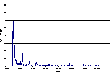
The flyers were mailed to the public on May 12 and a program was developed to analyze the webserver logs to track the number of floodplain queries from the new interface. In order to assure a reasonable use estimate or count, the log files were searched for specific address location queries. Multiple requests for the same address were eliminated to obtain a more meaningful estimate of the number of floodplain requests. These requests were then plotted to show the number of requests per day. Figure 3 shows the floodplain requests for the period May – November 2006. In addition to the web access logs, District front office staff responded to phone calls from the public requesting that floodplain maps be sent to them by either mail or email. These calls were logged and tracked along with the web requests. In total, it was estimated that 868 map requests were made to the webserver and only 64 requests required manual handling. This means just fewer than 4% of the flyers sent out resulted in requests for additional information. While this number seems low, it was not surprising considering the direct mail method of contacting homeowners and tenants. The pleasant surprise was that only 7% of the requests required personal assistance from District staff while the other 93% was accomplished via the SVG interface.
During the course of the summer of 2006, three updates to the underlying GIS data layers were performed. The first was a replacement of the highways and roads coverage. A new coverage was obtained from the Colorado Department of Transportation (CDOT), which was not only statewide but included all street names in the attribute table. This allowed the user to mouse over a street and confirm the name of the street or highway from the interface. In addition, two updates to the floodplain layer were performed as new GIS information became available. These new coverages were imported into a new table in the central database and tested. When the results were verified, the main SVG file was simply updated to point to the new data. This would not have been possible with the 2004 version. The new SVG interface developed for the District allowed a highly detailed, interactive floodplain hazard mapping interface. This level of detail and interaction was possible via the ability of SVG to integrate raster and vector data in one display. |
||||||||