ALERT Web Server EnhancementsBy Chad A. Kudym, GIS Administrator, Information Services and Flood Warning Program
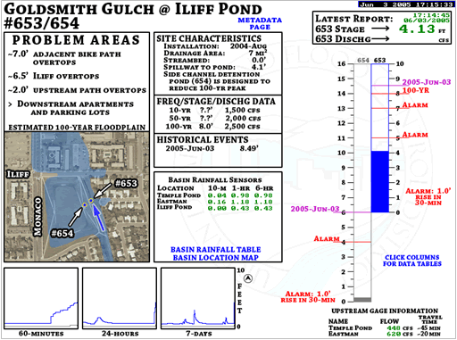
The Information Services and Flood Warning Program staff is routinely working on ways to improve access to ALERT data and create additional decision support tools. In 2006, the District’s ALERT webserver was updated with new stream gage and weather station graphics for a select set of stations. The graphics include more data to help local governments make decisions about potential flood threats. This development will continue into 2007. The new streamgage graphics (right), now include the following: problem areas, overview aerial map, site characteristics, frequency/stage/discharge information, historical events, basin rainfall data (including map and table links), adjustable-scale hydrographs (60-minute, 24-hour and 7-days), metadata page link, latest report data, staff gage illustration with labels (alarm settings, historical high water marks and frequency marks) and finally upstream and downstream gage flows (with estimated travel time). The overview aerial map illustrates the gage location and the extent of the 100-year floodplain to help users assess the relative threat to life and property.
Weather stations in the District ALERT network help provide information leading up to storm events. Often times the meteorologists in the Flash Flood Prediction Program provide specific criteria associated with the potential for storm development. Such criteria usually involve a temperature and dewpoint combination that will initiate convective activity. The weather station graphics will help users monitor surface conditions in their area in advance of storm development. |
||
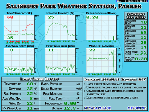 The new weather station graphics (below), display 24-hour trends for several sensors. The graphics include trend graphs for temperature, dewpoint, relative humidity, precipitation, wind speed, peak wind gust, wind direction and barometric pressure (where available). The precipitation graph is a bar graph that displays a bar for each 30 minutes of accumulation. The graphics also include statistics for the past 24-hours and a section displaying the latest sensor reports. The date and time below each of the graphs displays the timestamp of the latest report to help users determine if the reports are recent. As with other graphics that users are familiar with, the weather station graphics include navigation features called “hotspots” that provide hyperlinks to a table of data reports for further data analysis.