Flood Warning Program Activities
by
Kevin G. Stewart, P. E.
Project Engineer, Floodplain Management Program
20 Years of Flood Prediction & Notification
1979-82 |
The GRD Weather Center |
1983-89 |
Henz Kelly and Associates (HKA) |
1990-98 |
Henz Meteorological Services (HMS) |
The District's Flash Flood Prediction Program (F2P2) just completed its 20th year of
providing local governments with early forecasts of flood potential, internal alerts and
warnings. Congratulations to John Henz who has served as the District's private
meteorologist since 1979. John has been involved with three businesses in providing the
contract services to the District.
In 1998, messages were issued on 33 days including 3 days in May, 3 in June, 14 in
July, 12 in August and 1 in September. Flash flood warnings (Message 3) were issued on
four days (July 25, 30, & 31, and August 21). With the arrival of the Denver monsoon
beginning July 22, the next two-week period was marked by messages being issued every day
except 7/27 and 8/2. What began as a very dry drought-like summer ending wetter than
normal with the South Platte River basin receiving the highest rainfall amounts in the
State (205% of July average) according to the Natural
Resources Conservation Service.
ALERT System Use & Expansion
The District ALERT base station logged over 4900 modem connections during 1998
representing over 3500 hours of connect time. This represents a 113-percent increase in
remote use time compared to last year's record-breaker of 1640 hours. It appears that
Colorado's 1997 flood disasters may have contributed to this dramatic increased interest
in real-time flood data. These numbers do not represent total system usage since seven
other base stations are also operating in the service area. Many new users are rapidly
becoming aware of the availability of ALERT data on the Internet. The ALERT Web Server may be accessed from the
District's home page (http://www.udfcd.org/).
The District provides its local government partners and certain other cooperators with
free dial-up access to the base station. In addition to ALERT data displays, a full suite
of weather products is also available including watches, warnings and advisories from the
National Weather Service; and heavy precipitation outlooks, quantitative precipitation
forecasts and internal message status reports from HMS.
The Douglas County flood detection network (FDN) project is nearing completion with 5
of 6 sites fully operational. This FDN consists of 3 weather stations and 3 rain/stream
gages. Final site selection for the East Plum Creek gage is one remaining task. It is
anticipated that this station will be in the vicinity of Castle Rock. The other two stream
gages are located on West Plum Creek at Pine Cliff Road and on Cherry Creek at Castle Oaks
Road. The weather stations are located at Highlands Ranch, Parker and Castle Rock. A local
flood warning plan will be developed with Douglas County in 1999.
ALERT data is currently available from 143 gaging stations comprising 124 rain gages;
69 water level sensors and 13 weather stations.
A new FDN project is expected to start next year for the Upper Sand Creek basin in
Aurora. A preliminary design has been completed with five new ALERT stations proposed. The
total expected cost for this expansion is $60,000 with the District and Aurora cost
sharing equally in the project. Once completed, the Sand Creek basin will be monitored by
a total of 28 rain gages and 19 stream gages combining existing FDNs for Toll Gate Creek
and Westerly Creek along with two other main stem gages on Sand Creek downstream of I-225.
1998 Floods
No federal flood disasters were declared in Colorado in 1998, but heavy rains and
significant flooding continued to plague the Colorado front range much like the summer of
1997, which will be long remembered for the deadly July 28 flash flood in Fort Collins.
Twelve other Colorado counties also received flood disaster declarations in 1997. With last year's events fresh in everyone's mind,
flooding concerns in the Denver metropolitan area remained high and the 1998 storm season
proved itself worthy of this attention.
 |
ALERT Record Rainfall July 30,
1998
Salisbury Park Weather Station in Parker |
| 1-min |
5-min |
10-min |
30-min |
60-min |
Total |
0.24" |
0.83" |
1.54" |
3.07" |
3.19" |
3.43" |
Thursday, July 30:
In 20-years of measuring heavy rainfall with ALERT gages, this day marks the maximum
measurement of rainfall intensity and storm total by the ALERT system. It is also
interesting to note that this measurement was made at a new site installed just this year
in Parker. The accompanying table shows the duration and corresponding maximum rain
amounts measured at the Salisbury Park weather station on July 30. At one point in the
storm, rainfall intensities were approaching 20"/hour. According to the ALERT
equipment vendor, Panama is the only other location known to have measured rain
intensities of this magnitude with an ALERT tipping bucket. The NOAA precipitation
frequency atlas estimates the 5-minute, 100-year intensity at 9"/hour.
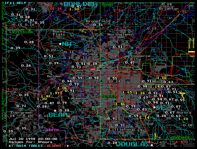
Click on BOULDER or DOUGLAS for more maps
A flash flood warning for the Parker area was issued based on both the
precipitation forecast and the real-time rain observations from the Parker gage. HMS and
District staff initiated the conversation with the NWS that led to the warning. This
represents another landmark event illustrating how local programs in partnership with the
NWS benefit the public by enhancing the early warning process. Richard Brandt, Acting
Public Works Director for Parker, felt that the July 30 early warning was a very good
decision.
Local streets and small drainageways in Parker were hit hardest by the
flooding, while no major damages to private properties occurred. The worst stream flooding
was reported along Sulphur Gulch and Tallman Gulch, but damages there were also low since
development has been kept outside the floodway and above 100-year levels. Cherry Creek
experienced an estimated 5-year event based on a field survey conducted by Leonard Rice
Consulting Water Engineers for the District. The USGS stream gage on Cherry Creek at Main
Street was damaged by floodwaters. The effluent discharge pipe from the Parker wastewater
treatment plant was buried under 4 feet of sand in Sulphur Gulch.
Coordination with the news media by District staff resulted in
excellent coverage and documentation of the flooding at Parker. Video taken from the KCNC-News 4 and KMGH-News 7 helicopters was especially useful.
Parker was not the only area hit on July 30; with Denver street flooding, zodiac boat
rescues at "Lake Logan" (Logan Street underpass of I-25) and a kayaker rescue
from the S. Platte River at Santa Fe being the lead stories for the evening news.
|
| Friday, July 31:
A flash flood watch was issued by the NWS shortly after 2 p.m. for the entire front range
from Colorado Springs to Fort Collins. At approximately 6 p.m., a flash flood warning was
issued for western Douglas County. Local authorities considered evacuating homes in the
Sedalia area but no action was needed. In Denver, street flooding damaged private property
in the vicinity of Evans Ave. and Lipan Street. Buffalo Creek flooding was the top news
story. This Jefferson County mountain community has sustained numerous floods since a
forest fire ravaged the area in May of 1996. Three inches of rain in one hour was reported
to have fallen at Buffalo Creek causing extensive road damage, large debris accumulations,
and disrupting electric, phone and water service for the night. Mudslides were a problem
for a number of other mountain towns that evening. |
| Monday, August 10:
While no flash flood warning was issued for the August 10 storm, extensive urban flooding
did occur in Lakewood and Denver. Between 4:45 and 5:45 p.m., 3.26 inches of rain was
measured in Lakewood near the intersection of W. 1st Ave. and Balsam Street. Rush-hour
traffic was at a crawl while many homes had their basements flooded. Vehicles were
floating in the Wal-Mart parking lot where the floodwater was 3 to 4 feet deep. This
parking lot is located in the floodplain of South Lakewood Gulch near W. 2nd Ave. and
Wadsworth Blvd. East of Kipling Street, McIntyre Gulch was out of its banks at a number of
locations. Lakewood Gulch in Denver overtopped Wolff St. by at least 3 feet. This event
contributed directly to a Lakewood City Council action exactly 2 weeks later endorsing a
plan to form a storm water utility and establish a fee of 88 cents a month for each 1000
square feet of impervious area, costing the average home owner $1.98 per month. |
|
1998 Peak Flows: This table lists some of the more notable
peak flows measured by the ALERT System in 1998.
|
Date/Time |
Location |
Peak (cfs) |
May 6 @ 23:07 |
Bear Creek above Cold Spring Gulch |
560 |
July 25 @ 18:54 |
Broomfield Basin 3207/Pond 6 |
* 470 |
July 25 @18:56 |
Harvard Gulch Park |
470 |
July 25 @ 19:09 |
Goldsmith Gulch at DTC/Temple Pond |
510 |
July 25 @ 19:12 |
S. Platte River at Dartmouth Ave. |
5,390 |
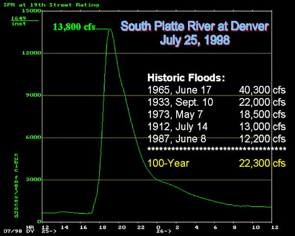
July 25 @ 20:04 |
S. Platte River at 19th Street |
13,800 |
July 25 @ 20:34 |
Holly Dam |
126 |
July 25 @ 20:46 |
Toll Gate Creek at E. 6th Avenue |
810 |
July 26 @ 00:20 |
Englewood Dam |
160 |
July 30 @ 17:46 |
Lena Gulch below Youngfield Street |
125 |
Aug 19 @ 21:15 |
Westerly Creek at Montview Blvd. |
720 |
Aug 22 @ 04:52 |
Sand Creek Park near I-225 |
400 |
Oct 16 @ 13:48 |
Ralston Creek at Carr Street |
1,170 |
* Indicates new record. |
Friday, August 21:
At 4:19 p.m., the NWS issued a flash flood warning for NW Elbert, south central Arapahoe
and extreme NE Douglas Counties. The storm was centered over Coal Creek just outside the
District in Elbert County, east of Parker and north of Elizabeth. Newspapers reported that
up to six inches of rain fell in Elbert County with two county roads under water much of
the evening. Roads in Arapahoe County were also closed. Coal Creek and Murphy Creek join
to form Sand Creek near Buckley ANG Base in Aurora. The 1998 peak discharge at the Sand
Creek Park ALERT gage below I-225 occurred nearly 12 hours later (see table).
|