

|
|
Flood Warning Program Activities
| ||||||||||||||||||||||||||||||||||||||||||||||||||||||||||||||||||||||||||||||||||||||||||||||||||||||
|
|
|
|
|
|
|
|
|
|
|
The District’s data appears to be coming quite popular.
Prior to developing the website, ALERT users had to either connect directly to the District’s system by modem or request data from District staff. Now, only a handful of requests for data and remote access privileges are received annually. Due to an increasing demand for historic data, the District recently added archive data retrieval capabilities to the website. Users can now obtain data online from as far back as August 21, 1985 when the first PC-XT base station became operational. Many local government users still desire the ability to dial-in to the ALERT system, which is sometimes necessary when the Internet gets busy like during local severe weather events. To better accommodate these users, the District recently acquired a site license upgrade for new Windows-based software known as "Remlynx," replacing the old REMDOS graphic terminal software. Remlynx is designed for modern PCs and is capable of modem and Telnet connections.
ALERT system expansion in 2001 consisted of four stations:
Funding agreements with Denver and Aurora were signed in December allowing further network expansion in 2002. One project will cover Marston Lake area in southwest Denver and the other will involve the Upper Sand Creek basin. New weather stations will be installed at Marston Lake and Aurora Reservoir. DIAD Incorporated may install a third weather station at their Longmont offices to facilitate testing of sensors and new equipment designs. DIAD provided the 2001 ALERT maintenance services for the District and Boulder County. More stations also appear to be on the horizon. Within the past month the City of Boulder expressed the desire to install at least two new rain/stream gages along South Boulder Creek downstream of Eldorado Springs. With such a high level of interest by so many, it is difficult to predict just how big the network will grow.
Days having flood potential |
||
| April | None | 0 |
| May | 2-5,27-28,30 | 7 |
| June | 7,13-14,20-21,26 | 6 |
| July | 5-15,23-26,31 | 16 |
| August | 1-2,6-9,13-15,22,30 | 11 |
| September | 14-15 | 2 |
The 2001 flood season may be remembered most for one week of particularly wet weather at a time of the year when hot and dry tends to be the norm. The week ending July 14 had flash flood warnings on three days (8,10,13), flash flood watches for three others and a mid-week break with only marginal flood potential. July 8, without question, produced the worst flooding of the year for the District. Fortunately, the storm happened on a Sunday or it would have affected many Denver area commuters and the consequences might have been worse. The following briefly describes some of the year’s more notable events:
Three days of steady upslope rain saturated soils along the Front Range. Rainfall amounts totaled 2 to 3 inches over much of the District causing some minor street flooding while larger streams like Cherry Creek and the South Platte River rose above normal. Two reservoirs monitored by the ALERT system recorded their annual peaks on May 5 (see table). No rainfall rate alarms occurred during this 3-day wet period.
| 2001 Peak Flows. Some of the more notable peaks measured by the ALERT system. | ||
| DATE/ TIME |
LOCATION | PEAK IN CFS |
| May 5 11:15 |
Maple Grove Reservoir on Lena Gulch | 20 (Elev. 5527.1) |
| May 5 20:21 |
Englewood Dam | * 156 (Depth 17.6') |
| June 9 03:45 |
Boulder Creek near Orodell | ** 630 |
| July 5 19:46 |
Westerly Creek at Montview Blvd. | 500 |
| July 5 20:06 |
Havana Park Detention | 350 (Depth 7.6') |
| July 8 04:44 |
South Platte River at Henderson | 7,160 |
| July 8 17:13 |
Goldsmith Gulch at Eastman Avenue | 2,030 |
| July 8 17:15 |
Harvard Gulch at Jackson Street | 820 |
| July 8 17:16 |
Harvard Gulch Park at Logan Street | * 2,080 |
| July 8 17:25 |
Goldsmith Gulch at DTC/Temple Pond | 640 * (Depth 14.5') |
| July 8 17:27 |
South Platte River at Dartmouth Avenue | 2,730 |
| July 8 18:24 |
South Platte River at 19th Street | 9,220 |
| July 8 18:27 |
Holly Dam | * 138 (Depth 19.8') |
| July 8 19:02 |
Cherry Creek at Steele Street | * 2,240 |
| July 8 19:30 |
Cherry Creek at Champa Street | * 3,230 |
| July 10 20:57 |
Niver Creek Detention | 60 (Depth 13.4') |
| July 13 19:02 |
Ralston Creek at Carr Street | 1,020 |
| July 23 16:49 |
Slaughterhouse Gulch Detention at Grant St. | 120 (Depth 7.0') |
| July 23 16:44 |
South Platte River at Union Avenue | 1,540 |
| * New record **
Peak due to snowmelt Click here for a complete listing of high water records |
||
While the District was under a low threat flood potential, the small community of Ellicott east of Colorado Springs was hit by a tornado leveling the high school and some mobile homes. Minor street flooding and 1" diameter soft hail was reported in Lakewood. This day is probably considered Colorado’s worst weather disaster of 2001.
At 7:20 p.m., heavy rain and damaging hail struck DIA causing more than $49 million in damage. That estimate did not include undisclosed damages sustained by the airlines at DIA. Between 40 and 50 mobile homes were also damaged in the Watkins area. Messages concerning the possibility for storms were issued for the entire District at 4:10 p.m. No major flooding was reported.
Fast-moving storms accompanied by high winds dropped 1.85 inches in less than an hour over Aurora during the rush hour. Rainfall rate alarms occurred at four ALERT gages in the general vicinity of I-225 and Sand Creek. Annual peaks were recorded for three stream gages in the same area. This day marked the beginning of 11 straight days of flood potential for the District and a 45-day siege of monsoon storms for the region.
Serious street and stream flooding hit Denver hard between 4 and 6 p.m. The storms were accompanied by high winds and small hail. Damage to the Cherry Creek Arts Festival was a major news story where one person was taken to the hospital after being struck by blowing debris from street displays. Flash flooding was observed on Harvard Gulch, Goldsmith Gulch, Cherry Creek, the South Platte River, and along I-25 where the infamous "Lake Logan" (Logan St./I-25 underpass) once again stopped traffic. The Harvard Gulch at Jackson Street rain gage measured the heaviest rainfall of 0.67" in 5 minutes and 2.48" in an hour. Additional reports of flash flooding were noted in Centennial and Englewood.
This was the main record-setting day for the ALERT system with rainfall rate alarms occurring at 17 stations. Annual peaks were recorded by 16 stream gages with 5 breaking their historic marks. The District and affected local governments were made aware of this day’s flood potential before noon, thanks to the forecasting talent of Bryan Rappolt. In the morning the NWS did not believe the threat warranted a flash flood watch, but as conditions worsened in the afternoon appropriate flash flood warnings were issued.
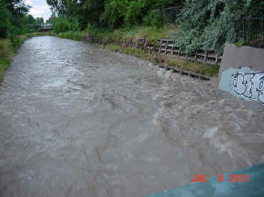 |
Goldsmith Gulch upstream of Mexico Avenue on July 8, 2001. |
A reconstitution of the storm performed by HDR Engineering showed that rainfall totals might have exceeded 4 inches along Colorado Blvd. between I-25 and Evans. The Harvard Gulch rain gage mentioned above is in this area and may have experienced considerable undercatch due to high winds—a well-known accuracy problem for ALERT rain gages. Harvard Gulch did experience a record flood, but it is somewhat unclear why the extent of flooding wasn’t worse with much of the upper basin receiving more than 3 inches of rain according to the HDR study. Further study will be needed to answer this question.
This event came very close to causing much greater property damage. More serious consequences were avoided for two main reasons: 1) existing flood control and drainage improvements prevented major damages; and 2) the rain stopped before the capacity of these facilities was exceeded. Another inch of rain and we would be telling a different story.
Click here to view a PowerPoint™ presentation of the July 8 flood presented by Bill DeGroot at the 2001 CASFM conference in Steamboat Springs.
| INSTRUCTIONS: The above referenced PowerPoint presentation contains 61 slides that were NOT initially developed for web use. Consequently, individual images may take considerable time to download. A high speed digital Internet connection is recommended for viewing this material. Please be patient! |
More information coming soon on the July 8 flooding in Denver…
A fast developing storm formed over central Jefferson County dropping 1.5 inches in 35 minutes while a second foothills storm hit the Evergreen area with similar amounts. A flash flood warning was issued by the NWS for upper reaches of Bear Creek above Evergreen where one-hour radar rainfall estimates exceeded 3 inches. Rain rate alarms occurred at 8 stations and 4 annual peaks were recorded.
Dual "Friday the 13th" storms deluged Arvada and Aurora. Radar-estimated rainfall of 2 to 3.5 inches was noted in northern Arvada over Little Dry Creek An observed 1.7 inches in less than an hour caused heavy runoff in the Toll Gate Creek basin and along Sand Creek in Aurora. Rain rate alarms occurred at 9 stations and 10 stream gages record annual peaks.
A long track multi-cell storm complex developed over the northwestern Jefferson County foothills about 3 p.m. The storm produced severe weather in the form of damaging hail and high winds across the foothills north of Golden, Rocky Flats, Broomfield and west-central Adams County. A Thornton official reported the heaviest rainfall amount of 3.7 inches, which caused serious street flooding. High winds and heavy rain produced street flooding problems in northern Aurora, near Barr Lake, and at DIA. Intense rainfall was also measured by the ALERT system in the Parker area.
A highly localized storm impacted rush hour traffic around the Denver Tech Center. Hail, wind and rainfall amounts exceeding 1.2 inches in 30 minutes slowed travel on I-25 and I-225. Funnel clouds were also reported. The South Platte River gage at Union Avenue recorded its record flow for the year, as did the Slaughterhouse Gulch detention basin at Grant Street. Rainfall rate alarms occurred once again in the Goldsmith and Harvard Gulch basins, but the flooding was not nearly as severe as July 8.
The "final" big storm day of 2001 hit the Boulder and Jefferson County foothills with four active storms dropping more than one inch in 30 minutes. The heaviest rainfall was noted over Morrison (1.61"), Turkey Creek (1.50"), and South Boulder Creek (1.34"). Rain rate alarms were triggered by 6 ALERT gages and 2 stream gages in the Bear Creek basin recorded their annual peaks. Very active lightning accompanied these storms.
[ Up ] [ Cover Story ] [ Tucker Talk ] [ Floodplain Mngmt ] [ Flood Warning ] [ CoCo RaHS ] [ Master Planning ] [ Stormwater ] [ Construction ] [ Maintenance ] [ Maint Eligibility ] [ South Platte River ] [ Activities ] [ News Briefs ]