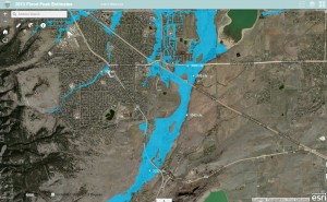
On May 16, 2019 the Colorado Department of Natural Resources / Colorado Water Conservation Board released an executive summary entitled: 2019 Flood Season is Approaching. While the South Platte River basin is not the State’s greatest flooding concern this year, temperature and precipitation outlooks suggest that streamflows from snowmelt runoff in the Denver/Boulder region will be much higher than last year. For information about the current snowpack conditions, visit https://alert5.udfcd.org/nrcs-snotel/.
All posts by wpadmin
Mission
Paramount to UDFCD’s mission is the personal health, safety and welfare of all people that live and work in the Denver metropolitan area and of many visitors that come to enjoy this incredible gateway to the Rocky Mountains.
UDFCD’s flood warning services are primarily oriented toward individual flood safety that requires protective actions to be taken on the part of those individuals to achieve the desired outcome–no lives lost. For flood warnings to be effective, people must first be aware of the flood risks they are living with and take appropriate steps to protect themselves when floods threaten.
Communities play a major role in educating residents about flood dangers and how to stay safe during floods. Actions taken before a flood like purchasing flood insurance, implementing measures to reduce risks to property, having a home or business emergency plan, practicing the plan, keeping emergency supplies on hand including a ‘Go Pack’, and evacuating when advised by local authorities will help assure that you and your loved ones are safe when the worst happens.
UDFCD’s Flood Warning & Information Services program works with communities to achieve this vision by providing local officials with early notifications concerning heavy rain and flood threats in partnership with NOAA’s National Weather Service. Local officials act on these notifications according to their respective emergency plans and warn people in affected high risk areas when a flooding threat becomes more likely.
In addition to providing flood predictions, UDFCD helps communities develop more efficient ways to detect and recognize flood threats. The ALERT System is one reliable way to monitor weather conditions, rainfall and stream levels in real-time. This early flood detection network is operated and maintained by UDFCD. It is used extensively by emergency managers, public works officials, fire departments, law enforcement, meteorologists, hydrologists, engineers, local news broadcasters, and the general public. NWS forecasters frequently make use of this valuable resource for issuing public flood advisories and flash flood warnings.
UDFCD’s Annual Newsletter
The 2015 issue is now available.
Read about:
Commemorating the 50th Anniversary of the 1965 Flood
Legislation to Protect Stormwater Detention in Colorado
Updates to the Urban Storm Drainage Criteria Manual
Ecological Restoration of Lower Boulder Creek
Support Activities for Stormwater Quality & Permitting
Extending Discharge Ratings for Water Resources Streamgages
UDFCD’s 2015 Program Activities
and more…
Flood Hazard News – December 2015
CRS Flood Warning & Response Credits
A service of the National Hydrologic Warning Council
NEW WEBSITE EXPECTED
The National Flood Insurance Program Community Rating System
- FEMA CRS-610 Flood Warning & Response credits
- Lakewood, Colorado program
- 2015 CRS Assessment (prepared for the Urban Drainage and Flood Control District in Denver, Colorado)
- Ventura County, California
Other Resources
- Colorado Water Conservation Board’s CRS Website
- US Army Corps of Engineers Risk Management Center
A Guide to Public Alerts and Warnings for Dam and Levee Emergencies
NHWC News Center
New ArcGIS Map
We recently improved one of our Esri ArcGIS Online maps that you may find useful. The new map shows flood hazard areas, September 2013 flood peaks and hydrography for major drainageways within UDFCD. Stream names can be displayed by clicking on the streams. A link can be found on our ALERT System website from the Maps menu.
Blinking Alarms
A recent update to ALERT GMap causes active alarms to blink and stop blinking when the alarm becomes inactive. When you click on the blinking station you will see the actual time that the alarm occurred and the threshold that triggered the alarm.
Click here to see a Flash™ video of this feature.
Wednesday Webinars
On July 16, 2014 we broadcast our first in a series of short instructional webinars offered to help local officials improve their storm/flood monitoring and emergency response capabilities, and keep apprised of relevant changes. That training focused on how to make best use of the ALERT System GMap website, which is one of the more popular features available from https://alert5.udfcd.org.
A Windows Media Player-compatible recording of this webinar is now available. You can download it from www.udfcd.org/FWP/ALERT/trainingvideos/.
To receive notices regarding future webinars simply subscribe to the FRAUG list at this website.
Alarm Log Update
The ‘alert5’ alarm log output has been updated to include a threshold column. Click here to see the alarm log for September 9-15, 2013.
Alarm logs can be accessed from both the GMap Data Menu and the TABLES webpage. Use your browser refresh button to update the alarm log during events.
ALERT Map & Server Changes
A number of changes have been made this past month to improve the performance of the ALERT Map and timeliness of the XML files that are used by other real-time applications.
- A second NovaStar-5 server is now fully operational. This backup server mirrors the primary server database at Diamond Hill, is remotely located, and will failover automatically should the primary server become disabled. The backup unit also permits load sharing of data processing task. This means that XML files accessible from cloud services can be updated more frequently. Currently all rainfall, water level and weather data files are updated every minute.
- The ALERT Map is one application that benefits from the dual-server implementation. Users should note more reliable automatic 1-minute data refresh rates.
- Other changes to the ALERT Map include:
- NWS warning area polygons are turned on by default and provide one-click access to the corresponding NWS warning product. Just click on the icon attached to the polygon to read the NWS warning.
- WDT looped Radar images are turned on by default reflecting the last hour of activity. All Radar images have their opacity set for 50%, allowing users to easily see the base map. All gaging station readouts overlay on top of the Radar images.
- Color coding is applied to all ALERT stage and discharge readouts to reflect threat conditions. The colors correspond to NWS AHPS threat levels with the exception of the blue readout, which represents bankfull conditions.
- USGS and DWR streamgage readouts are displayed on the stage and discharge maps using darker green backgrounds to distinguish their data from the ALERT data. Links to corresponding webpages supported by the USGS and Colorado DWR can be found by clicking on the readout.
- Time series plots and links to tabular data are available for all ALERT readouts including measured water levels, discharge estimates and rainfall.
We hope you find these improvements useful. As always, your comments and suggestions are welcome.