-
A quarterly publication of the National Hydrologic Warning Council
Read the most current issue at…
The NHWC public website
Please read the ALERT data disclaimer and see note below concerning winter operations.
CAVEAT: All data obtained from this system is considered provisional. Always inspect raw data carefully to verify rainfall amounts, water level measurements and other information.
TYPE CODES & ABBREVIATIONS:
P=rain/precipitation, S=stage/water level, Wx=weather station, R=repeater, TB=tipping bucket, PT=pressure transducer, SE=shaft encoder, WS/WD=wind speed/direction, TX=transmitter, RF=radio frequency
| PROBLEMS |
| 4413 Fourmile at Salina out of service due to road construction |
| 4423 Bridge over Boulder Creek damaged by highway construction |
| 4843 SBC at Cannon Ditch out of service |
| 8802 Fourmile at Logan Mill Rd OOS due to road construction |
| DISCONTINUED STATIONS |
| 1330 Roslyn (P) |
| 1630 South Platte River at Dartmouth (S) |
| 1810 Sand Creek at mouth (PS) |
| 2190 Mestaa’ėhehe Mountain (Wx) |
| 1420 Diamond Hill (Wx) |
| NEW STATIONS |
| A2-10087 Rotolo Park (PS) |
| RAIN GAGES AFFECTED BY LAWN IRRIGATION | ||
| 420 Expo Park | 600 Harvard Gulch Park | 750 Quincy Reservoir |
| 430 Utah Park | 630 Temple Pond | 830 Side Creek Park |
| 500 Havana Park | 640 Goldsmith at Eastman | 850 Flying J Truck Plaza |
| 510 Virginia Court | 720 Confluence Pond | 1500 Powers Park |
| RAIN GAGES IMPACTED BY WILDLIFE | |
| 200 Leyden Lake | 220 Upper Leyden |
| 410 Kelly Road Dam | 610 Harvard Gulch at Jackson |
| 710 Horseshoe Park | 720 Confluence Pond |
| 730 No Name Creek at Quincy | 1100 Louisville Rec. Center |
| 1200 Broomfield Basin 3207 | 1600 Englewood Dam |
| 1900 Niver Detention | 4060 Lakeshore |
Most ALERT rain and stream gaging stations are shutdown for the winter and made ready for the next flood season. Boulder County mountain rain gages remain in operation over the winter to assure ready status for early spring storm monitoring. All weather stations and repeaters operate year-round along with the following stage gages:
| WINTER OPERATIONS | |
| 203 (A2-10088) Leyden Lake | 1003 Maple Grove Reservoir |
| 1649 SPR at 19th Street | 1659 SPR at Henderson |
| 1703 Cherry Creek at Champa | 2333 Bear Creek at Morrison |
MHFD assists Boulder County with maintaining ALERT stations in the Boulder Creek and South Boulder Creek watersheds. Boulder County maintains the Saint Vrain Creek and Left Hand Creek stations.
System maintenance is performed by OneRain and WET.
Report problems to Bruce Rindahl.
DENVER, April 15, 2021 – Today the Mile High Flood District launched its 43rd annual flash flood prediction program. This early notification service alerts local authorities from the 7-county Denver/Boulder metro area of developing flood threats, operating in partnership with the National Weather Service.
A large network of rain and stream gauges provides continuous monitoring of threatening weather and flood conditions. Twitter users can receive notifications from the ALERT System when heavy rainfall is occurring in the region.
Forecasters at Skyview Weather provide essential support by calling 911 communications when flooding is imminent. Critical information is then relayed to appropriate response agencies.
As we enter the 2021 flooding season, MHFD urges everyone to heed flood warnings by: 1) taking protective actions recommended by NWS and public safety officials; 2) avoiding trail use near streams during heavy downpours; 3) keeping away from floodwaters while on foot or in a vehicle. Remember that most flood fatalities are people who perish in vehicles.
Before flooding impacts your neighborhood, take some time to learn about flood risks near your home, school and workplace; and consider purchasing flood insurance to protect yourself financially. Most property insurance policies do not cover flood losses.
Above all, stay flood safe!
About the Mile High Flood District:
MHFD was established by the Colorado legislature in 1969 to protect people, property and our environment by working regionally with local governments to address drainage and flood hazards. This is accomplished through a combination of preservation, mitigation and education activities. MHFD serves a population of approximately 3 million from Denver and parts of the six surrounding counties that include 35 incorporated cities and towns.
For more information, visit www.mhfd.org
Contact: Kevin Stewart, kstewart@mhfd.org, 303-455-6277
To: All F2P2 Partners
In compiling our notes for this year, we wanted to give everyone a chance to weigh-in on any flooding events that may have impacted your communities or you personally. As most of you already know, 2020 had very few rainstorms capable of causing serious flood impacts making this year our least impactful since the F2P2 began 42 years ago.
To help with your recall, here are the storm dates that likely produced daily rainfall amounts of 2” or more:
| DATE | LOCATION(s) POTENTIALLY IMPACTED | NOTES* |
| May 24 | General widespread, low intensity rainfall | max GARR >3.29”, no rain alarms |
| June 26 | Arapaho, Boulder, Denver, Douglas & Jefferson Counties including Aurora and Lakewood | max GARR >2.97”, greatest number of rain alarms for a single day in 2020 |
| July 4 | Aurora & southern Douglas County | max GARR >3.41” |
| July 9 | Adams County (Barr Lake area northwest of DIA) | max GARR >2”, no rain alarms |
| July 19 | extreme SE Aurora & Arapahoe County | max GARR >1.96” |
Intense rainfall exceeding 3 inch-per-hour rates occurred on other days , but total rainfall for those days was under 2 inches. For 2020 rainfall intensity/duration/frequency measurements, download the PeakRain Excel workbook.
Any information you can send us will be most appreciated. Thank you for all you do to keep your communities safe.
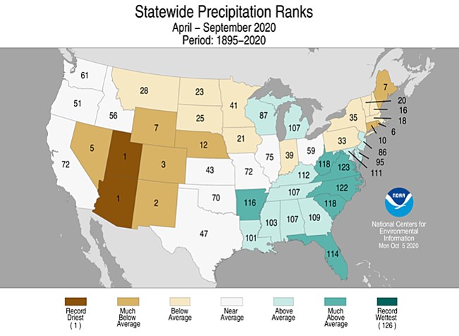
Final closing climate trivia…2020 was Colorado’s 3rd driest year on record.
Kevin Stewart, P.E.
Engineering Services Manager
MILE HIGH FLOOD DISTRICT
2480 W. 26th Ave Suite 156-B | Denver, Colorado 80211
Office: 303-455-6277 | Direct: 303-749-5417 | www.mhfd.org
Protecting People, Property, and our Environment

On May 16, 2019 the Colorado Department of Natural Resources / Colorado Water Conservation Board released an executive summary entitled: 2019 Flood Season is Approaching. While the South Platte River basin is not the State’s greatest flooding concern this year, temperature and precipitation outlooks suggest that streamflows from snowmelt runoff in the Denver/Boulder region will be much higher than last year. For information about the current snowpack conditions, visit https://alert5.udfcd.org/nrcs-snotel/.
Paramount to UDFCD’s mission is the personal health, safety and welfare of all people that live and work in the Denver metropolitan area and of many visitors that come to enjoy this incredible gateway to the Rocky Mountains.
UDFCD’s flood warning services are primarily oriented toward individual flood safety that requires protective actions to be taken on the part of those individuals to achieve the desired outcome–no lives lost. For flood warnings to be effective, people must first be aware of the flood risks they are living with and take appropriate steps to protect themselves when floods threaten.
Communities play a major role in educating residents about flood dangers and how to stay safe during floods. Actions taken before a flood like purchasing flood insurance, implementing measures to reduce risks to property, having a home or business emergency plan, practicing the plan, keeping emergency supplies on hand including a ‘Go Pack’, and evacuating when advised by local authorities will help assure that you and your loved ones are safe when the worst happens.
UDFCD’s Flood Warning & Information Services program works with communities to achieve this vision by providing local officials with early notifications concerning heavy rain and flood threats in partnership with NOAA’s National Weather Service. Local officials act on these notifications according to their respective emergency plans and warn people in affected high risk areas when a flooding threat becomes more likely.
In addition to providing flood predictions, UDFCD helps communities develop more efficient ways to detect and recognize flood threats. The ALERT System is one reliable way to monitor weather conditions, rainfall and stream levels in real-time. This early flood detection network is operated and maintained by UDFCD. It is used extensively by emergency managers, public works officials, fire departments, law enforcement, meteorologists, hydrologists, engineers, local news broadcasters, and the general public. NWS forecasters frequently make use of this valuable resource for issuing public flood advisories and flash flood warnings.
Commemorating the 50th Anniversary of the 1965 Flood
Legislation to Protect Stormwater Detention in Colorado
Updates to the Urban Storm Drainage Criteria Manual
Ecological Restoration of Lower Boulder Creek
Support Activities for Stormwater Quality & Permitting
Extending Discharge Ratings for Water Resources Streamgages
UDFCD’s 2015 Program Activities
and more…
Flood Hazard News – December 2015

A service of the National Hydrologic Warning Council
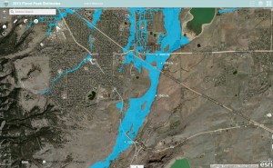
We recently improved one of our Esri ArcGIS Online maps that you may find useful. The new map shows flood hazard areas, September 2013 flood peaks and hydrography for major drainageways within UDFCD. Stream names can be displayed by clicking on the streams. A link can be found on our ALERT System website from the Maps menu.
