
![]()
![]()
|
|
Maintenance Program Activities
| ||||||||||||||||||||||||||||||||||||||||||||||||||||||||||||||||||||||||||||||||||||||||||||||||||||||||||||||||||||||||||||||||||||||||||||||||||||||||||||||||||||||||||||||||||||||||||||||||||||||||||||||||||||||||||||||
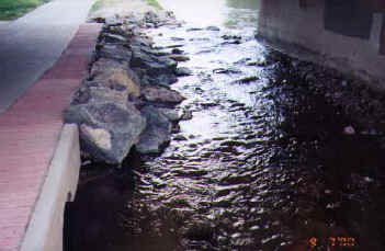 |
An example of a recovery zone on Cherry Creek. |
For its last three miles, before it discharges into the South Platte River, Cherry Creek flows in a vertical concrete-walled channel through central Denver. Approximately 70% of the edge of the low flow channel through this reach is lined with boulders. At the gaps in the protection the creek can still threaten the concrete walls or the nearby trail. When we repair this type of erosion near the trail we also install a two-foot wide recovery zone at the edge of the trail. This will help warn persons that they are in danger of going off the edge of the trail. It also gives them additional width in which to regain the main trail surface.
Little Dry Creek crosses under the Highline Canal south of Orchard Road in
Arapahoe County. Downstream from the irrigation canal crossing steep-banked erosion on the
creek is threatening private property. The owner of the canal and the private property
owner are both willing to participate with us in funding the project to accelerate the
erosion control work. This is a good example of cooperation among multiple parties to
address a common problem. We enjoy doing this kind of project because the result is very
often a multi-purpose improvement with many pleased parties.
STATUS OF MAINTENANCE REHABILITATION PROJECTS |
||||
| Project | Jurisdiction | Cost |
Status | |
| ADAMS COUNTY | ||||
| Little Dry Ck., Shaw Heights. -
South of 80th. Repair bank erosion, partic. |
Westminster | Design | $65,000 |
100% |
| Const. | 600,000 |
90% | ||
| Sand Creek -confluence w/ S.
Platte R. Repair bank erosion, participation |
Commerce City | Design | 14,600 |
25% |
| Const. | canceled |
canceled | ||
| ARAPAHOE COUNTY | ||||
| Big Dry Creek – east of
University Blvd Repair to channel and trails |
Arapahoe County | Design | $41,050 |
60% |
| Const. | next year |
0% | ||
| Cherry Creek – west of
Colorado Blvd. Repairs to outlet of tributary. |
Glendale | Design | 10,000 |
100% |
| Const. | 25,000 |
100% | ||
| East Toll Gate Trb. - Along Uravan
Av Drops and channel repair |
Aurora | Design | 70,950 |
90% |
| Const. | next year |
0% | ||
| Little Dry Ck. – east of
Holly at Arap. Sediment trap and park repairs, partic. |
Arapahoe County | Design | 41,800 |
70% |
| Const. | canceled |
canceled | ||
| Little Dry Ck – Quincy to
Belleview Av Grade control at sewer crossings partic. |
Cherry Hills Village | Design | by others |
100% |
| Const | 100,000 |
0% | ||
| S.J.C.D. North – East of
Sheridan Bvd. Repair low flow channel and drops. |
Arapahoe County | Design | 34,387 |
100% |
| Const. | 350,631 |
10% | ||
| Willow Creek, Jamison Trib. –
Dry Ck Road. Repair drop structures, partic. |
Arapahoe County | Design | by others |
100% |
| Const | 329,888 |
100% | ||
| BOULDER COUNTY | ||||
| Coal Creek – west of Erie at
r.r. tracks Rebuild obliterated channel |
Erie | Design | by others |
75% |
| Const. | canceled |
canceled | ||
| Elmer’s Twomile Ck. – s.
of Iris Ave. Rebuild detention pond and channel |
Boulder | Design | by others |
85% |
| Const. | next year |
0% | ||
| DENVER COUNTY | ||||
| Cherry Creek – W. of Colorado
Blvd. Repair drop structure |
Denver | Design | $66,697 |
100% |
| Const | 220,424 |
100% | ||
| Cherry Creek – Highline canal
crossing. Repair drop structure, participation |
Denver | Design | 19,985 |
70% |
| Const | next year |
0% | ||
| Cherry Ck, Babi Yar T.-Yale
&Havana Drops, bank repair |
Denver | Design | 45,320 |
100% |
| Const. | 328,967 |
100% | ||
| Harvard Gulch – Through
DeBoer Park Rebuild trickle channel |
Denver | Design | 39,845 |
80% |
| Const | next year |
0% | ||
| Lakewood Gulch – In Martinez
Park Trail repairs, participation |
Denver | Design | by others |
100% |
| Const | 6,000 |
100% | ||
| Lakewood Gulch – Federal to
Knox Channel erosion repair |
Denver | Design | 83,432 |
100% |
| Const. | 394,647 |
95% | ||
| South Platte River, Westside Trib.
- N.E. of 6th and I-25. Install pipe. |
Denver | Design | 82,868 |
100% |
| Const. | 334,278 |
100% | ||
| DOUGLAS COUNTY | ||||
| Sulphur Gulch – W. of Hwy
#83. Rebuild drop structure |
Parker | Design | $77,940 |
100% |
| Const. | 281,000 |
20% | ||
| Tallman Gulch – In Rowley
Downs trail construction, participation |
Parker | Design | by others |
100% |
| Const | 75,000 |
100% | ||
| JEFFERSON COUNTY | ||||
| Dutch Ck – NE. of Pierce
& Coal Mine Repair eroding channel |
Jefferson County | Design | $76,558 |
100% |
| Const. | 458,010 |
100% | ||
| McIntyre Gulch – Union at
Alameda Pk Repair erosion and drops, participation |
Lakewood | Design | 63,910 |
100% |
| Const. | 300,000 |
10% | ||
Twenty-two projects were at various stages of design or construction during 2000. Those projects are listed in the accompanying table titled "STATUS OF MAINTENANCE REHABILITATION PROJECTS". Rehabilitation projects usually take the form of consultant-designed repairs that are intended to address severe problems that have occurred on a previously improved urban drainageway. By the end of 2000 the District will have spent about $3,077,100 on rehabilitative design and construction for the year. A few of the unique projects are discussed below.
Shaw Heights Tributary joins Little Dry Creek at Sheridan Boulevard and 76th Avenue in Westminster. Upstream from that point Shaw Heights Tributary passes through a small park. Above that it is compressed into a narrow corridor between a railroad track and residential backyards. Construction of drop structures and a geocellular confinement system to provide bank stabilization is nearing completion.
We have learned that there are drawbacks to designing multiple phases of a lengthy project and then building those phases over several years as funds become available. As the plans sit on the shelf new design concepts are developed, neighborhood concerns change, and political directions are amended. This frequently results in a construction plan that is obsolete before it is built. The goal of the channel reconstruction on Dutch Creek east of Pierce Street was to correct bank erosion near a pedestrian bridge and to stop a headcut from eroding through a wetland. The original design had been done seven or eight years ago. Much of that design had to be redone this year as a result of the factors mentioned above plus the topographic changes that had occurred in the project area.
Southwest of Federal Boulevard and Colfax Avenue Lakewood Gulch flows through the rolling landscape of Sanchez Park. The original design for this work was begun 10 years ago. This design also had to be revised, more than once, for the same reasons mentioned in the paragraph above. The work, which is currently under construction, will install drop structures and boulder edging in select locations on the low flow channel to arrest the erosion and protect the corridor’s Cottonwood trees.
Construction is now being completed on the West Side Tributary to the South Platte River northeast of 6th Avenue and I-25. This project sat on the shelf for five years waiting for funding and because of a conflicting sewer line construction project that needed to be completed before this project could begin. While waiting for its turn this project was also redesigned to updated standards. But, that was not the last change as construction of this project revealed another dilemma. The channel drained an industrial area from early Denver. The water was contaminated with residual petroleum products which in turn had contaminated the soil throughout the length of the project. Dealing with the tainted soil in the proper manner caused a 56% cost overrun over the original bid.
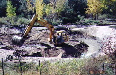 |
Cleaning out the Willow Creek sediment trap. |
In the previous two issues of Flood Hazard News we have reported on the sediment trap that was constructed on Willow Creek at Dry Creek Road in Arapahoe County. It has been in operation since early summer of 1999. In early fall of 1999 we removed nearly 1000 cubic yards of accumulated sediment from the facility. We have done two sediment removals so far this year with each being about 800 cubic yards. It is a small sediment trap with a holding volume of about 0.6 acre-feet serving a drainage basin of over eight square miles. It is not capable of capturing the fine sediments but, it has served well in catching the sandy and granular material.
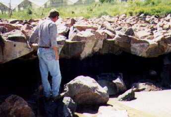 |
Channel erosion on Sulphur Gulch below the drop structure. |
Flowing from east to west through the center of downtown Parker is sandy-bottomed Sulphur Gulch. In 1994 a grouted sloping boulder drop structure was built on Sulphur Gulch about two thousand feet upstream from its confluence with Cherry Creek. There are no grade control structures on the gulch downstream of the drop structure. The consequence has been rapid and destructive erosion of the channel bed below the drop resulting in the collapse of the lower edge of the structure. A construction contract to repair the structure is now underway.
In the early and mid-1980s the Maintenance Program rehabilitated six drop structures on Cherry Creek between University Boulevard and Holly Street in Denver. We rebuilt all six of them as sloping riprap drop structures making use of the existing sheet pile as the cutoff wall for our new drops. Each of the rebuilt drops starting failing almost immediately. Areas of the riprap appeared to be undersized and, in general, riprap is only as strong as its weakest area. With the completion of the reconstruction of the structure west of Colorado Boulevard in May, 2000 we have now re-rebuilt five of them as grouted sloping boulder drop structures.