
![]()
|
|
Flood Warning Program Activities
| ||||||||||||||||||||||||||||||||||||||||||||||||||||||||||||||||||||||||||||||||||||
Days having flood potential |
||
| Apr | None | 0 |
| May | 17,25 | 2 |
| Jun | 27 | 1 |
| Jul | 10,12,14,16-17,20 | 6 |
| Aug | 13,15-18,21,24-31 | 14 |
| Sep | 1 | 1 |
Messages were issued to local governments on 23 of the 24 days listed in the table, setting a record low for the 22-year period of F2P2 operations. Sunday, August 13 was the "miss" when unexpected storms developed over central Jefferson County near Morrison and just south of the District in Douglas County causing brief heavy rainfall near Castle Pines. Both events lasted only 20 to 30 minutes, dropped just over an inch of rain, and covered areas of less than two square miles. No flooding was reported from either event. On August 13 and four other days (July 16&17 and August 17&29), the ALERT system triggered rainfall rate alarms due to 1" amounts falling in less than one hour. On two other days (August 18&28), street-flooding rainfall rates of 0.5" in 10 minutes were measured by ALERT gages. Two NWS flash flood warnings were issued in the District for July 16 and August 17, and a flash flood watch has issued for July 17. The following briefly describes some of the more notable events:
| 2000 Peak Flows. The table lists some of the more notable peaks measured by the ALERT system. | ||
| Date/ Time |
Location | Peak in cfs |
| May 17 17:25 |
Harvard Gulch Park at Logan Street | 350 |
| June 20 12:59 |
Boulder Creek near Orodell | ** 610 |
| July 16 22:02 |
Westerly Creek at Montview Blvd. | 460 |
| July 16 23:04 |
Goldsmith Gulch at Eastman Avenue | 370 |
| July 17 00:12 |
Havana Park Detention | * 540 |
| July 17 00:44 |
Ralston Creek at Carr Street | 2,300 |
| July 17 00:50 |
Harvard Gulch at Jackson Street | 270 |
| July 17 01:36 |
Cherry Creek at Steele Street | 1,230 |
| July 17 02:00 |
Maple Grove Resv on Lena Gulch | 24 |
| July 17 04:44 |
South Platte River at Henderson | 9,260 |
| Aug 17 16:52 |
Slaughterhouse Gulch Detention | * 140 |
| Aug 17 17:05 |
Goldsmith Gulch at DTC/Temple Pond | 340 |
| Aug 17 17:14 |
South Platte River at Union Avenue | 1,700 |
| Aug 17 17:38 |
South Platte River at Dartmouth Avenue | 2,300 |
| Aug 17 18:32 |
Holly Dam | 112 |
| Aug 17 19:27 |
South Platte River at 19th Street | 5,690 |
| Aug 18 00:04 |
Englewood Dam | * 161 |
| Aug 29 21:49 |
Niver Creek Detention | 64 |
| * New record ** Peak due to snowmelt Note: A complete listing of record high water measurements for ALERT stream gages can be found at http://www.udfcd.org/FWP/alert.htm |
||
Snowplows were needed in along C-470 near Highlands Ranch for this first flash flood threat day of the 2000 flood season. The media reported grape-sized hail up to 6" deep and rainfall totals of 1.7" in Brighton, Aurora and Parker. The ALERT gage at the Highlands Ranch Water Treatment Plant measured 1.93" after the hail had melted. The maximum precipitation amount in the network (2.13") was recorded near Smoky Hill and Gun Club Roads in SE Aurora. No significant stream flooding was reported. Storms plagued much on NE Colorado on this day with 23 tornadoes being reported, but no serious injuries. Messages calling for street/nuisance flooding potential were in effect between 10:30 a.m. and 3:00 p.m.
After nearly two months with only five days of limited flood potential, the widespread rains of July 16 attempted to recover the region’s moisture deficit. It was during this extended dry period that two major Colorado wildfires caused record damage in Jefferson and Larimer Counties ("Hi Meadow" and "Bobcat" Fires). The July 16 storms produced rainfall rate alarms at 16 gaging stations in the ALERT network. Rainfall amounts exceeded 0.5" throughout much of the system while peak totals approached 3" at a number of locations. The higher measured amounts occurred in the Lena Gulch and Ralston Creek drainage basins in Arvada, Lakewood, Wheat Ridge and unincorporated Jefferson County. The Ralston Reservoir gage recorded the highest rainfall total (3.70"). The day’s rain resulted in at least 8 annual peak stream gage measurements (see table). The Havana Park detention basin gage, located in Aurora’s Westerly Creek basin near 11th and Havana, broke its 13-year high water record at 12 minutes past midnight. The NWS issued a flash flood watch for the Front Range foothills from noon until midnight. With rain accumulations approaching critical thresholds at some locations, a flash flood warning was issued for NE Jefferson County at 8:24 p.m. No major flood problems were reported.
The District escaped the flood threat on this day but areas in extreme northwest Elbert County were less fortunate. Flooding in the upper Box Elder Creek basin washed out County Road 13 near Elizabeth and caused other problems in town. By the time the floodwaters reached the District/Arapahoe County border, the peak had attenuated and no problems were reported. A flash flood watch had been in effect for the entire District from noon to 10 p.m.
This day will be remembered for the sad loss of Denver fire fighter, Bob Crump, who died in the line of duty after rescuing a woman from floodwaters in the vicinity of E. 49th Ave. and Colorado Blvd. The map shows rainfall totals for a 5-hour period ending at 8 p.m. The 2.64" amount shown for Commerce City is closest to the location where Bob Crump lost his life after being pulled into a submerged open 36" storm sewer. The storm at this location was estimated to be a 75-year event.
The flooding that was realized this day was somewhat unexpected. Morning analysis indicated minimum flood potential, but weather conditions changed substantially by mid-afternoon. At 3:32 p.m., HMS meteorologist Bryan Rappolt issued a message for Arapahoe County calling for strong thunderstorms capable of producing 0.5" to 1.5" in 15-30 minutes with hail as large as 0.5" possible. The message was valid from 3:45 to 8:00 p.m. and the risk to life and property was considered low. Subsequent messages followed, but this was the first notice of any potential flood threat. Within the next 10 to 15 minutes, heavy rainfall was occurring over northern Douglas County and the Littleton area. By 4 p.m., the NWS had issued an urban and small stream flood advisory for this storm and at 4:37 p.m. the advisory was upgraded to a flash flood warning for a large portion of the Denver metropolitan area.
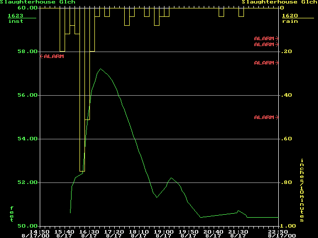
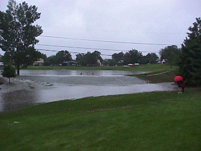
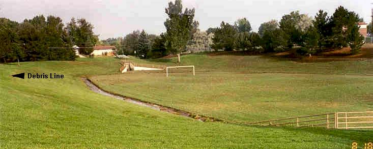
Slaughterhouse Gulch through the City of Littleton was one area hit hard by this storm (see 2.36" amount on map). In 1998, the District's Construction Program completed storm drainage improvements to the upper basin, thus allowing new detention facilities to begin providing some relief to properties downstream. This multi-phase project was initiated in 1985 with the City of Littleton and Arapahoe County. The Grant Street detention basin near Orchard and Broadway performed well during this event, filling to a record depth of 8.1 feet (see figure). Damages were certainly prevented at this location. Another detention basin further downstream at Powers Park overflowed, resulting in some significant property damage to a duplex in the floodplain along West Berry Drive. The Powers Park facility was designed to handle up to a 10-year storm, which was exceeded on August 17. The peak flow table shows six other ALERT streams gages, in addition to the Slaughterhouse gage, that measured annual peaks from this storm.
Between 7:30 and 9:00 p.m., a large thunderstorm produced heavy rainfall over Commerce City, Thornton and western Adams County causing some localized flooding. The storm dumped up to 2" of rain in 20 to 40 minutes and was accompanied by frequent cloud-to-ground lightning. The Niver Creek detention basin at 88th and I-25 measured its annual peak on this day. This was the last significant rain event of the 2000 flood season.
The 2000 flood season marks the year with the fewest days with messages issued (23, average is 35, record high 52 in 1996), the fewest number of verified message days (20), and the lowest number of message days for June and July (1 and 6 respectively). ALERT data is currently available from 144 gaging stations (126 rain gages, 64 water level sensors and 15 weather stations).