 A number of changes have been made this past month to improve the performance of the ALERT Map and timeliness of the XML files that are used by other real-time applications.
- A second NovaStar-5 server is now fully operational. This backup server mirrors the primary server database at Diamond Hill, is remotely located, and will failover automatically should the primary server become disabled. The backup unit also permits load sharing of data processing task. This means that XML files accessible from cloud services can be updated more frequently. Currently all rainfall, water level and weather data files are updated every minute.
- The ALERT Map is one application that benefits from the dual-server implementation. Users should note more reliable automatic 1-minute data refresh rates.
- Other changes to the ALERT Map include:
- NWS warning area polygons are turned on by default and provide one-click access to the corresponding NWS warning product. Just click on the icon attached to the polygon to read the NWS warning.
- WDT looped Radar images are turned on by default reflecting the last hour of activity. All Radar images have their opacity set for 50%, allowing users to easily see the base map. All gaging station readouts overlay on top of the Radar images.
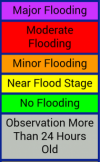
- Color coding is applied to all ALERT stage and discharge readouts to reflect threat conditions. The colors correspond to NWS AHPS threat levels with the exception of the blue readout, which represents bankfull conditions.
- USGS and DWR streamgage readouts are displayed on the stage and discharge maps using darker green backgrounds to distinguish their data from the ALERT data. Links to corresponding webpages supported by the USGS and Colorado DWR can be found by clicking on the readout.
- Time series plots and links to tabular data are available for all ALERT readouts including measured water levels, discharge estimates and rainfall.
We hope you find these improvements useful. As always, your comments and suggestions are welcome.