|
by
Kevin G. Stewart, Project Engineer, Floodplain Management Program
District Acquires Flood Prediction Center
Since June of 1988, the District's Flash Flood Prediction Program (F2P2)
has operated from the Diamond Hill Office Complex at 2480 West 26th Avenue in Denver. In
fall of 1998, Henz Meteorological Services (HMS) chose to move their business from this
location to Littleton. This gave the District an opportunity of secure dedicated office
space at Diamond Hill for future F2P2 operations. This represents a fundamental change for
the District, considering that the F2P2 has operated from the offices of the private
meteorologist since its start in 1979. The program's satellite downlink system, emergency
power generator and other existing rooftop communications equipment at Diamond Hill
factored heavily in the District's decision to develop a more permanent Flood Prediction
Center. Remodeling of the 1,119 square-foot FPC in Suite 310-B was recently completed. The
FPC will continue to be staffed by a private meteorologist during the flood season from
15-April through 15-September. HMS provided the forecasting services for 1999.
ALERT System Notes
Like many other Millenium-frustrated computer owners, Y2K is
forcing the District to make some significant changes to the ALERT system. Since the first
IBM PC/XT base station was purchased by the District in 1985, a UNIX-like operating system
(OS) known as QNX has been in use. This highly reliable OS has evolved over the years to
accommodate new computer technologies, but its basic design has remained essentially
unchanged. The popularity of Internet TCP/IP communications and the desire by software
developers to make the "old-reliable" OS more UNIX compatible, has lead to its
obsolescence. Consequently, the District will be replacing QNX-2 with the "new
improved" QNX-4 system. It was not surprising to learn that, in addition to the OS
upgrade, some other costly software changes would also be required--specifically, the
ALERT database/display software. While this may sound relatively simple, consider the
following facts: 1) the existing 15-year-old database and archive files must be converted
to a new format; 2) many existing custom features must be individually revised; and 3)
maintaining a similar "look and feel" is desirable to minimize operator
retraining needs. It should be clear that we do have a major project ahead. One irony in
all of this is that the existing QNX-2 operating system is entirely Y2K-compliant.
Computer hardware upgrades are also necessary since all seven
District-supported base stations currently use 486 processors and other components that
are not Y2K-compliant. Considering the software challenges mentioned above, replacing the
hardware appears the easy part.
A new flood detection network (FDN) is being considered for southwest
Denver in the vicinity of Marston Lake. The preliminary investigation for this ALERT
expansion project should be completed by summer 2000 with implementation funding possible
before yearend.
ALERT Weather
Station near Elbert |
 |

Sonic Anemometer
|
 |
ALERT Mesonet growth continued in 1999. Additional weather stations are
also planned for 2000. The newest weather station in this network was installed near
Elbert in June. This platform incorporates new sonic wind sensing technology with no
moving parts. The figure illustrates the physical science principles and mathematics used
to calculate wind speed. Traditional spinning-cup anemometers and wind vanes use bearings
that require periodic replacement and it is difficult to detect when these instruments are
failing. Thus far, the wind data collected from the Elbert station appears quite good. A
second sonic anemometer will soon be operating at a new weather station site on Squaw
Mountain in Clear Creek County south of Idaho Springs.
The Denver Department of Environmental Health recently asked the
District to help install an ALERT weather station at The Urban Farm at Stapleton as part
of the District's regional gaging network. The Urban Farm occupies the building formerly
used by National Weather Service. The NWS forecast office was relocated to Boulder in May
of 1998. The DEH will provide 100-percent of the funds needed to purchase and install the
station. The District will assist DEH with future maintenance.
The Urban Farm's mission is to teach agricultural and environmental
education to children, youth and their families though links with schools from Denver and
the surrounding area. Learning modules will include studying floodplain management
practices, land use controls, how urban growth impacts stormwater quality, and the affects
of urban development on streamflow and flooding. The idea of having access to weather data
from the entire ALERT mesonet was very attractive to the project. This will also be a new
learning experience and educational outreach opportunity for the District.
Counting the Urban Farm weather station and the possibility of another
weather station near Marston Lake, the ALERT mesonet is expected to grow to 17 stations by
the end of 2000.
The District ALERT base station logged over 3900 modem connections
during 1999 representing over 2200 hours of connect time. These numbers reflect a slight
downward trend compared to the previous year’s record of 4900 logins/3500 hrs. This
may be indicative of the milder flood season that we experienced, or it may be that users
are beginning to prefer the Internet access alternative found at 'alert.udfcd.org'. The
District provides local government agencies and certain other cooperators with free
dial-up access to the base station. With network communications and web browser usage part
of our daily routines, ALERT users can expect the District to continue improving Internet
capabilities in 2000.
1999 Floods & Threats
Certain parts of Colorado were declared federal flood disasters
during 1999. La Junta in Otero County was hardest hit when spring floodwaters from the
Arkansas River overtopped flood control levees causing damage to more than 200 homes.
Eleven other Colorado counties were later added to the federal disaster list. District
local governments once again avoided flood "disaster" but did not make it
through the flood season completely unscathed. As usual, localized flood damages occurred
in the Denver area on a number of days this past year. The following briefly describes
some of the more notable events.
 | April 29 - May 1
On April 30 and May 1, the NWS issued flood watches for the South Platte
River and other large Denver area streams. Gradual rises in river stage were observed due
to relatively high rainfall accumulations over the prior week. ALERT rain gages in Boulder
County had 7-day rainfall totals approaching six inches, but fortunately no high intensity
rains occurred during this period. Englewood Dam recorded a record high water depth of
16.2 feet on April 30. Spillway flows begin at a depth of 40 feet. Flood control
improvements to this District-owned, normally dry detention dam were completed in 1976.
The ALERT station for this site has been in operation since June 11, 1987.
|
| Thursday, May 20
This was the first flash flood threat day of the 1999 flood
season, with the Carr Street gage on Ralston Creek in Arvada providing one of the
verification statistics (see table for annual peak). Ralston Creek did overtop its bank in
places but no major flood damages resulted. Heavy rain also occurred in Denver at a number
of locations. The first Message 1 internal alert was issued by HMS at 2:29 PM, followed 30
minutes later by a Red Flag update message.
|
| Friday, June 11
Winter appeared to have returned to southern Douglas County
when an intense storm brought 8 to 12 inches of hail to the headwaters of Cherry Creek
near Franktown and Larkspur. A warehouse roof collapsed injuring three workers while two
dozen others escaped uninjured according to the Rocky Mountain News. While heavy rain and
hail caused some minor street flooding in the metro area, the District was not impacted by
the Douglas County storm. Messages were issued by HMS at 12:47 PM alerting District
counties of the potential for one-inch rains lasting 30 to 45 minutes accompanied by
1" diameter hail between 2:00 and 10:00 PM.
|
| Monday, June 14
Aurora received the heaviest rain amounts causing problems for some local
drainage facilities. The Sable Ditch rain gage exceeded its alarm threshold three times
during the storm. A maximum intensity of 5.67"/hour was measured at 3:16 PM during
the 90-minute event which produced 1.61" of rain. Small hail also hindered storm
drainage system performance and may have caused some gages to underestimate rainfall.
|
| Wednesday, July 28
A massive rain-induced landslide near the headwaters of Clear Creek marked
the second anniversary of Fort Collins flash flood disaster. The slide covered I-70 with
more than 25 feet of mud east of the Eisenhower Tunnel causing the interstate highway to
be closed for 25 hours. At least five other road closures were also caused by mudslides
elsewhere in Colorado. In the Denver area heavy rains were measured at a number of gages
with the higher amounts being reported in Aurora (1.73" at Side Creek Park) where
alarm thresholds were exceeded at 4 sites. July 28 also represents the first NWS flash
flood watch issuance of the year affecting the District. The NWS watch was issued shortly
after 4 PM prior to the occurrence of heavy rain.
|
| Saturday, July 31
Rains near Georgetown caused two minor mudslides forcing closure of I-70
for the second time this week. In Denver and Aurora, street flooding kept public works and
police departments busy. Martin Luther King Blvd. in the Park Hill area of Denver was
barricaded due to flooding between Colorado Blvd. and Quebec Street. However, this measure
did not stop six motorists from driving into the flooded area and stalling. In Aurora,
water was above the curbs at a number of major intersections. Sand Creek recorded its
annual peak while the Havana Park detention facility in the Westerly Creek basin
overflowed into neighborhood streets. Flash flood warnings were issued for parts of
Jefferson and Boulder County outside the District. The ALERT system measured its highest
rainfall amount of 1.77" in the mountains of Boulder County between Nederland and
Ward. Thunderstorm rain in Denver and Aurora exceeded one inch at 8 gaging stations with
1.69" occurring at Horseshoe Park in Aurora. This day marks the 23rd anniversary of
the Big Thompson Canyon flash flood that killed 145.
|
| Wednesday, August 4
Few will argue that this was the worst flood day of the year for the
District with Massey Draw in Jefferson County being one of the hardest hit areas. A
District construction project at Carr Street received considerable damage along with five
homes in the area. North of Denver high water closed I-25 between 104th and 144th Avenues.
At U.S. 36 and I-25, a Toyota dealership was flooded ruining 45 cars with damages
estimated at $500,000. U.S. 36 was nearly impassible at Federal Blvd. where mud-clogged
storm drains made matters worse. CDOT maintenance crews were out until after midnight
Thursday cleaning up U.S. 36. A mobile home park along Niver Creek near 92nd and Pecos had
5 feet of water flowing through it around 4 PM. M. Scott Carpenter Middle School near 70th
and Mariposa reported 6 feet of water in the building. The school is located near Kalcevic
Gulch in Adams County. In Boulder County runoff from heavy rains damaged roads in Eldorado
Canyon State Park along South Boulder Creek. The NWS said that 2 to 3 inches fell in
Westminster and Federal Heights in 90 minutes. The storm activity began around 3 PM, just
before rush hour.

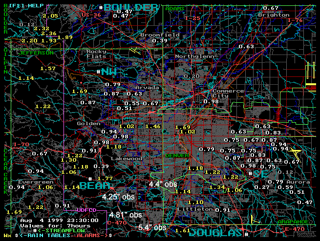
Composite photo taken August 5 looking downstream at Massey Draw
from Carr Street in Jefferson County. Road maintenance crews helped direct
water toward the channel during the storm by constructing a temporary earth dike across
street. |
|
The ALERT system reported rainfall totals not representative of the
flooding that occurred. Boulder County gages recorded the highest 24-hour amounts with six
mountain stations exceeding 3 inches. There are no automated gages in the Massey Draw
area, nor along Kalcevic Gulch or the northern portion of I-25. The ALERT map display
shows 7-hour rain totals ending at 11:30 PM. The larger numbers noted as "obs"
were obtain from the NWS and other observers in and surrounding the Massey Draw drainage
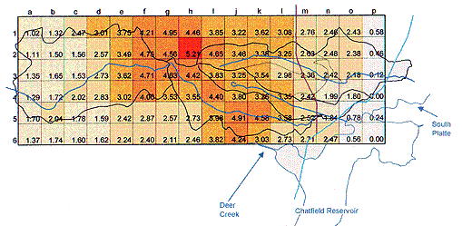
basin. Henz Meteorological Services was hired by the District to reconstruct the Massey
Draw storm using archived radar data and rainfall estimating techniques that they
developed for predicting flood potentials. The figure, taken from the HMS report, shows
1/2 miles square grids positioned over the Massey Draw basin with estimated rain depths
for the storm period between 4:30 and 6:30 PM. The rain activity actually lasted 6 to 8
hours and HMS estimates that the maximum rain depth may have exceeded 7 inches for that
period. Fortunately, most of the storm was characterized by relatively low rain
intensities or the flooding would have been much worse. The peak discharge estimated for
Massey Draw at Carr Street from high water surveys indicated that the event was much less
than a 100-year flood, more on the order of a 10-year event.
| Thursday, August 5
Given the flood problems from Wednesday and the highly saturated ground
conditions over much of the District, the NWS issued a flash flood watch lasting from noon
through 10 PM. While the Denver metro experienced a few localized storms, Bear Gulch in
the Box Elder Creek basin east of DIA was hardest hit by flooding. A dog kennel near E.
88th Ave. and Imboden Road in Adams County was flooded and a number of animals were
killed. The District had Leonard Rice Consulting Water Engineers obtain high water
measurements for this flood. The highest rain measured in the metro area was at Westwoods
in Arvada where 1.02" fell.
|
| Tuesday, August 10
The Wheat Ridge Municipal Building and Police Station experienced minor
flooding when parking lot runoff exceeded storm drain capacities and entered the building
around 4:30 PM. The problems were caused by a very intense short duration storm that swept
through the area, accompanied by high winds downing large tree limbs. A nearby ALERT
station (Upper Sloan Detention Basin) measured an unimpressive rainfall total of
0.47", but the storm lasted only about 6 minutes. The storm's high intensity was
estimated to be a 10 to 20-year event at this location. Elsewhere in the Denver area, more
than 3 inches was reported to have fallen in less than an hour. The highest ALERT rain
measurement was 2.52", near I-225 and Sand Creek in Aurora. In addition to the wind
and rain, hail and lightning caused problems for many areas including DIA. The earliest
HMS messages were issued for Jefferson, Boulder and Douglas Counties before noon. The 1:30
PM all District counties were notified of the potential.
|
| Thursday, August 19
Only one flash flood warning was issued by the NWS during 1999 that
affected the District, and it happened on this day at 5:21 PM. The warning specifically
mentioned East Toll Gate Creek in Aurora and was based on a 3.5" Doppler Radar
estimate from a stationary storm over a 60 to 90-minute period. The ALERT system recorded
a maximum measurement of 1.69" at Side Creek Park south of Buckley ANG Base. Further
upstream, amounts of 1.30" and 1.42" were measured. Local newspapers contained
reports of minor street flooding along Gun Club Road between E. Quincy and E. Mississippi
Avenues. From the data available, it appears that the Radar may have overestimated
rainfall for this storm by a factor of two. |

| Date/Time |
Location |
Peak in cfs |
| April 30/14:07 |
Holly Dam |
(Depth 11.8')
100 |
| April 30/16:54 |
Cherry Creek at Champa |
4,450 |
| April 30/20:06 |
Englewood Dam |
* (Depth 16.2')
153 |
| May 20/15:48 |
Ralston Creek at Carr Street |
2,300 |
| May 27/17:07 |
Bear Creek at Morrison |
660 |
| June 14/15:28 |
Sable Ditch at 18th Avenue |
220 |
| June 14/17:24 |
Sand Creek Park near I-225 |
210 |
| June 29/01:43 |
Boulder Creek near Orodell |
*** 690 |
| July 13/11:46 |
Ralston Reservoir |
* (Elev. 6047.4)
210 |
| July 19/18:08 |
Goldsmith Gulch at Eastman Avenue |
320 |
| July 28/19:04 |
W. Toll Gate Creek at Horseshoe Park |
930 |
| July 28/19:29 |
E. Toll Gate Creek at Buckley Road |
1,320 |
| July 31/19:21 |
Havana Park Detention |
(Depth 7.0') 100 |
| July 31/21:08 |
Sand Creek at mouth |
2,200 |
| Aug 4/19:25 |
South Boulder Creek near Eldorado Sprgs |
370 |
| Aug 4/22:36 |
Harvard Gulch at Jackson Street |
580 |
| Aug 5/00:03 |
South Platte River at Dartmouth Avenue |
3,510 |
| Aug 5/01:26 |
South Platte River at 19th Street |
5,670 |
| Aug 5/04:57 |
South Platte River at Henderson |
9,120 |
| Aug 10/16:56 |
South Platte River at 19th Street |
** 5,670 |
| Aug 10/15:41 |
Westerly Creek at Montview Blvd. |
720 |
| Aug 19/18:29 |
No Name Creek at Quincy Avenue |
320 |
* Indicates new
record
** Equals Aug 5 peak
*** Caused by snowmelt |
1999 Peak Flows. The table lists
some of the more notable peaks measured by the ALERT system in 1999.
Summary
During the 1999 flood season, the District's Flash Flood Prediction Program (F2P2) issued
messages to local governments on 45 days (1 in April, 8 in May, 6 in June, 14 in July, 13
in August, 3 in September). On 8 of these days, the ALERT system recorded rainfall rate
alarms caused by 1" amounts falling in less than one hour. On 12 other days,
street-flooding rainfall rates of 1/2" in 10 minutes were measured. The only NWS
flash flood warning issued within the District was for the Aurora storm of August 19.
Flash flood watches were issued for July 28 and 29 and for August 5. The F2P2 has been in
operation for the 21 years.
ALERT data is currently available from 143 gaging stations (125 rain
gages; 64 water level sensors and 14 weather stations).
[ Up ] [ Cover Story ] [ Tucker Talk ] [ Floodplain Mngmt ] [ Flood Warning ] [ Drop Structures ] [ Master Planning ] [ South Platte ] [ Stormwater Quality ] [ Construction ] [ Maintenance ] [ Software ] [ Novatech ] [ Awards ] [ Activities ]
|