![]()
Press Release Ready for Next Flood
Last year's Flood Hazard News reported that the District and the City of Arvada cooperated in publishing a Flood Protection Handbook and Post-Flood Recovery Assistance Plan. The project team focused primarily on Arvada's flood hazards and developed recommendations based on recent experiences of many disaster-stricken communities in other parts of the United States. While we believe this effort has better prepared Arvada and its residents for a large flood, the fact remains that Arvada with its estimated 1300 flood-prone properties has never experienced a flood "disaster." Consequently, it is difficult for many to perceive a flood problem or any personal risk.
The same may be said for most residents living in the Denver area with the 1976 Big Thompson flood approaching its 20th anniversary and fading from memory; with three large federal dams controlling floods on the South Platte River, Bear Creek and Cherry Creek making a repeat of the 1965 flood an "impossibility;" and with the District and its local government partners continuing to remedy many of the more troublesome drainage and flood problems. Given this complacency and knowing that floods remain the greatest potential hazard to people and property in Colorado, the District has taken one additional step to help citizens recover after a flood disaster by preparing a one page print-ready layout for local newspapers.
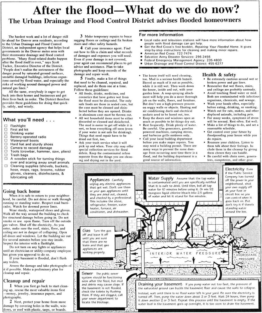
The press release was prepared by Jacquelyn Monday of Lakewood, Colorado, who also served as the technical editor for Arvada's Flood Protection Handbook. The "After-the-Flood" chapter of the handbook served as a guide for designing this page. This newspaper layout contains locally appropriate information advising homeowners and residents on what to do after being damaged by a flood. Only minor revisions like local contacts and phone numbers will be needed before releasing this information.
The District has incorporated procedures in its Flood Disaster Plan for issuing this
press release immediately after a flood has caused extensive property damage. We hope that
this page will never need to used but history teaches us that we should plan now for the
inescapable disaster. Local governments wanting information on how to develop their own
self-help programs may contact the District for assistance.
ALERT Rainfall Accuracy
In a recent ALERT Transmission newsletter, Dr. David C. Curtis, DC Consulting, Folsom, California, authored an excellent article discussing wind effects on rain gauge catch. Referencing available scientific literature, Dr. Curtis concluded that a reasonable undercatch estimate for unshielded ALERT tipping bucket rain gauges is one-percent per mile-per-hour of wind speed occurring at the height of the rain collector orifice for wind speeds of 30 mph or less. For higher wind velocities, the effects are more uncertain. Combine these uncertainties with the problem of obtaining real-time wind data at a ten-foot height at 113 gaging stations and we can safely conclude that wind-adjusted ALERT rainfall measurements will pose an interesting challenge for the future. Rain gauges can be shielded from wind to some extent but for standard 10-foot standpipe towers, constructing shields is not practical and aesthetically unacceptable in many cases. Trees and buildings may help reduce direct wind effects but may cause other problems which are even more difficult to quantify. In Oklahoma, mesh screens designed to minimize debris problems have been identified as an undercatch culprit by causing splash loss.
It is our opinion that ALERT rain gauges have to be well maintained and routinely tested in the field to give users confidence in the measurements they report. "Accuracy" is a relative term which all data users must understand. Providers of ALERT rain data should take time to educate data users concerning their definition for accurate and the various other data error possibilities. ALERT gauges can reliably measure heavy precipitation and give decision-makers early indications that critical rain thresholds are being exceeded. How accurate is this data? Probably accurate enough for flood detection purposes.
The District routinely attaches a written disclaimer in response to requests for ALERT
data.
Flood Threat `95
From May through July, many Coloradans were bracing for possibly the worst snowmelt runoff flooding in the past decade. The news media continuously reported information about this treat over the 3-month period. The state's first Flood Task Force, lead by Larry Lang of the Colorado Water Conservation Board (CWCB), held weekly meetings during May and June keeping the public well informed of flood potentials. The Jefferson County Department of Emergency Management formed a similar task force to address specific county concerns. The City of Boulder established two 24-hour telephone "hot lines" for the public to obtain general and emergency flood information. Many government agencies and volunteers joined with other public and private organizations in preparing for the worst. Fortunately, the worst did not occur.
After the spring floodwaters receded, CWCB and the Colorado Office of Emergency Management reported 15 flood-related deaths statewide and damage estimates approaching only $20 million. Most of this damage occurred outside the District. Agricultural land along the South Platte River in Weld and Logan counties, and 14 homes in Georgetown along Leavenworth Creek were identified as some of the areas hardest hit. Cool weather lasting until mid-June was credited for moderating the snowmelt across Colorado. Even with this help from mother nature, record water levels were reported in many reservoirs due to the large volume of runoff. This did not please many avid boaters, fishermen and beach enthusiasts wanting to return to Chatfield Reservoir and Bear Creek Lake for summer fun.
Bear Creek Lake, a federal flood control reservoir in Lakewood, set a new high water record of 5587.17 feet (MSL) on June 17. This elevation is 29 feet above the normal pool level and 6.2 feet above the previous record set on June 23, 1983. Bear Creek Dam was completed by the US Army Corps of Engineers in July of 1977. The Corps released a maximum outflow of 612 cfs on June 25.
Chatfield Reservoir, located on the South Platte River above Littleton, recorded its third highest water level since its completion in August of 1973. The lake level rose to an elevation of 5446.40 feet, peaking on July 4 just 1.18 feet lower than its May 26, 1980 record. A new record release of 3350 cfs was set this year on July 8. Chatfield Dam is also operated by the Corps of Engineers.
While the snowmelt flood threat received the greatest attention from the news media, peak streamflows at most locations in the District were caused by heavy rainfall, not melting snow. The heaviest measured rainfall was from a gauge operated by the Pinehurst Golf and Country Club where a reported 3.2 inches fell in less than one hour on the afternoon of Sunday, June 4. Pinehurst is located in extreme southwest Denver north of Marston Lake between Wadsworth and Sheridan Boulevards. Residential flooding and storm drainage problems were reported along a small south-bank tributary to Bear Creek just north of the golf course. The June 4 storm also caused flood problems in other parts of Denver, Englewood and Sheridan. This single thunderstorm produced the highest peak flows for the year along lower Bear Creek and the South Platte River through Denver. The following table summaries peak flows at selected stream gaging stations for this and other 1995 events:
1995 Peak Flows
| Location | Peak (cfs) | Date |
| Bear Creek at Morrison | 900 | June 18 |
| Bear Creek at Sheridan | 2,740 | June 4 |
| Cherry Creek at Steele St. | 1,100 | Aug. 18 |
| Clear Creek at Golden | 4,500 | June 19 |
| Goldsmith Gulch at Eastman | 900 | Aug. 18 |
| Ralston Creek at Carr St. | 1,470 | July 15 |
| Sand Creek at Brighton Blvd. | 1,400 | May 17 |
| S. Platte River at Dartmouth | 6,120 * | June 4 |
| S. Platte River at 19th St. | 10,800 | June 4 |
| S. Platte River at Henderson | 16,700 | May 17 |
* Errata December, 2000
The ALERT rain gauge network had only four locations which reported rainfall amounts exceeding 1-inch in less than an hour during 1995. These storms occurred on May 18, June 4, June 28 and July 15. An ALERT rain gauge in Arvada reported the heaviest amount of 1.61" in 25 minutes on July 15 at approximately 9:30 PM. This storm developed very rapidly near Standley Lake, moved slowly to the southeast, intensified over Arvada and forced closure of Colorado Highway 121 (Wadsworth Bypass) north of West 58th Avenue (Ralston Road). After causing Arvada and motorists some grief, the storm lost its energy and quickly dissipated, a very typical scenario for a late afternoon/early evening Front Range thunderstorm.
ALERT data is currently available from 130 gaging stations including: 113 rain gauges; 62 water level sensors located in streams, detention basins and reservoirs; and 8 weather stations. Anyone interested in obtaining ALERT data from the District may contact Kevin Stewart at (303) 455-6277 or fax your request to 455-7880.
![]()