![]()
![]()
|
|
Print VersionFloodplain Management Program Notes
| |||||||
|
Implementation of portions of our master plans, particularly regional detention facilities, is always a challenge. We continue to have some successes that I would like to highlight.
We completed an Environmental Assessment (EA) of alternatives for the Irondale Gulch watershed within the Rocky Mountain Arsenal (RMA). The comment period is complete and we are expecting a FONSI (Finding of No Significant Impact) at any time. The FONSI will allow us to move forward with intergovernmental agreements between the District, Denver and RMA; and between the District, Commerce City, Adams County and RMA for the construction, operation and maintenance of these facilities on the RMA.
I would like to acknowledge the assistance we received from Tim Kilgannon and Tom Jackson in guiding us through the EA and FONSI process.
Denver, Aurora and the District have agreed to fund the final design and construction drawings for a detention pond called Silverado II, which is to be located on Pena Boulevard right-of-way. We anticipate that a major developer in the area will construct a significant portion of the pond once the design is complete. We are also talking to two other developers about building three additional ponds called for in the master plan.
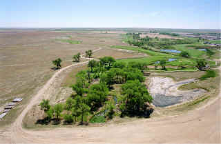
The Parkfield developers, represented by Ken Schmidt, have continued to implement portions of the Irondale master plan. In 2002, a connection was completed between the RMA and Parkfield Lake, a spillway was completed at the lake, and an inlet channel was partially constructed.
We did not complete any flood hazard area delineation (FHAD) studies this year. However, I'm reviewing two drafts as this is written. Both FHADs should be published in early 2003. One is for Cherry Creek from the reservoir to the District's upstream boundary. The other is for Little Dry Creek and Tributaries in Arapahoe County. Both are being completed as part of outfall systems planning efforts for the two watersheds.
We began a FHAD for Ralston and Leyden Creeks in Arvada in order to account for the effects of the new Leyden Lake Dam project on the downstream floodplains. We are also doing a FHAD for Kinney Creek and Fonder Draw in Douglas County as part of an outfall systems planning study. In 2003 I hope to begin re-studies of the South Platte River through Adams County and Clear Creek through Adams County.
All of these studies are prepared in digital form compatible with FEMA's Digital Flood Insurance Rate Map (DFIRM) specifications. This will make it easier to add these floodplains to the DFIRMs.
We are continuing efforts to put more information on our web site. One project in the works is a photo album of good projects. We are often asked for examples of good projects by developers and their consultants, and we thought that the web would be the best way to distribute this information, particularly as new projects are completed.
The photo album will have chapters on drop structures, pedestrian/bicycle bridges, low flow channels, formal channels, stormwater detention facilities, integrating the floodplain into a development, and multiple use facilities. As this is written there are photos in the first two chapters. We will be adding to the other chapters as time and good photos permit. To access the photo album, go to our web site and click the "Good Examples" button.
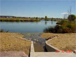
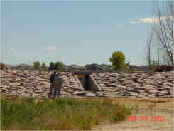
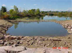
Parkfield Project Photos |
||
|
|
|
One of our publications is our "Activity Summary" that briefly describes the District and provides an overview of each of the District's programs. It also includes a large map that identifies all District studies completed or in progress. Unfortunately, we only publish the Activity Summary in January of odd numbered years, and the information regarding District studies is more and more out of date the further you get from the publication date.
To overcome that problem we are going to experiment with putting the map on the web site where we can frequently update the status of all our studies. We envision a process where the user can click on a given drainageway or watershed on the map and instantly obtain all the information we have on that drainageway or watershed, including completed study titles and dates, on-going studies, scheduled studies, and, perhaps, construction information as well. The map should be on our web site the first quarter of 2003.
[ Home ]