New Spillway Gates at Maple Grove Reservoir
By Mark R. Hunter, P.E., Manager, Maintenance Program
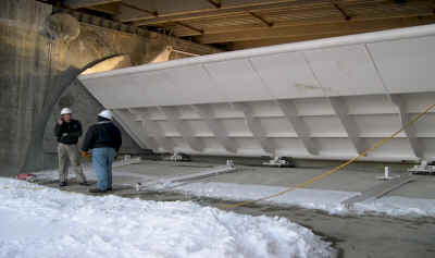
Maple Grove Reservoir; Dec, 2004 Looking at the
downstream side of the new 40-foot long by 10-foot tall steel crest gate
as it is being tested for the first time. |
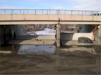
Maple Grove Reservoir, Dec, 2004 Looking north toward
the upstream side of the new 40-foot long (left) and 30-foot long steel
crest gates as they are being tested. |
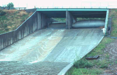
Maple Grove Reservoir, 1979 Looking south at spillway
and inflatable fabridams under the roadway bridge. The fabridams had been
installed about two years prior. This photo is near the time the 30-foot
dam on the left was sliced open and deflated by vandals. In this photo
both fabridams are fully inflated. |
By mid-December, 2004 the two new steel crest gates located in the spillway
of Maple Grove Dam were ready to hold back the water that was re-filling the
reservoir. The new gates replaced two inflatable dams (fabridams) that were
installed in 1977 and were near the end of their service life. The fabridams
were installed to improve the operational control of the reservoir and to reduce
spillway outflow to be in line with the flood-carrying capacity of the
downstream channel.
Maple Grove Reservoir is situated on Lena Gulch at 27th Avenue near
Youngfield Street in Lakewood, Colorado. Consolidated Mutual Water Company owns
the reservoir and uses it to store raw water. The water is eventually treated
and distributed to Consolidated's customers.
When Maple Grove Reservoir was constructed in 1955 it inadvertently provided
substantial downstream flood protection. This benefit to the communities
downstream of the reservoir was recognized in the 1975 Lena Gulch Drainage
Study.
In 1974, Consolidated was directed by the Colorado State Engineer's office to
enlarge the Maple Grove Dam spillway to pass the calculated Standard Project
Flood. This is the flood that would result from a storm with a recurrence
interval of 250 years in the Lena Gulch drainage basin upstream of the
reservoir.
Portions of Wheat Ridge, Jefferson County, and Lakewood benefited from the
flood protection provided by the reservoir. Along with the District, these
communities cooperated with Consolidated in 1976 to design a unique spillway
enlargement that met the needs of both Consolidated and the flood-prone
communities downstream of the reservoir.
The coordinated plan called for Consolidated to own the 30-foot long by
6-foot tall dam and the District to own the 40-foot long by 10-foot tall dam,
both of which were located in the newly-enlarged spillway. The dams in the
spillway allowed discharges through the spillway to be controlled by the
mechanically operated gates. The result was that the District and downstream
local governments could anticipate acceptable spillway outflows during 100-year
storm events while Consolidated could be confident in being able to withstand
the Standard Project Flood without overtopping the reservoir.
The fabridams were inflated by a combination of air and water and were
difficult to operate and maintain. They showed their vulnerability in March of
1979 when vandals using knives sliced open the 30-foot long dam allowing a
relatively small but certainly unexpected flood to occur. The peak flow
immediately below the reservoir was about 750 cubic feet per second and caused
some residential basement flooding and first floor damage to some commercial
buildings.
The replacement system uses hydraulic cylinders to raise and lower the two
independent crest gates. They will operate under the same discharge parameters
as did the fabridams. The new steel crest gates are more resistant to vandalism
and are far simpler to operate and maintain than the fabridams. The new system
affords renewed confidence in the integrity of Maple Grove Dam to the District,
Consolidated, and the communities downstream of the reservoir.