Combined with the steep channel slopes prevalent in Eastern Colorado the
result is often severe erosion, degradation, widening and lateral migration of these
channels.
Solution
Years of observations have shown us that on-site runoff reduction practices (mostly
on-site detention) have only a limited effect on mitigating the above-stated problems.
Studies in Maryland and Washington also confirm the fact that even small amounts of land
development (i.e., 10 to 15% of total imperviousness) change the 2-year (i.e.,
goemorphologically dominant flow) and smaller runoff flows dramatically. These effects are
amplified in semi-arid and arid regions because runoff from undeveloped catchments is
almost zero during a 2-year storm.
We have found that grade control structures, placed to reduce the
longitudinal slope of the natural channels, have not only accomplished the goal of
stabilizing degrading streams and gulches and protecting existing riparian zones, but have
been a very positive factor in encouraging further growth of a wide variety of wetland and
riparian vegetation. This has increased the wetland and wildlife habitat areas along the
channels of urban catchments in the Denver region. Although stream bank stabilization is
often also needed, grade control structures by themselves, installed before development
begins or in its early stages, have proven to be the most important feature in reducing
stream degradation and erosion. Its benefits also include the reduction of silting-in of
downstream aquatic habitat.
Examples
The remainder of this paper is devoted to case studies of various
projects we are aware of in which the installation of grade control structures had some or
all of the benefits described above.
Sand Creek in Aurora
Sand Creek was channelized by a developer in the 1960’s. At that time the channel was
straightened and steepened. Hundreds of houses were built in the 100-year floodplain, and
the City of Aurora and the District constructed a channelization project to remove them
from the 100-year floodplain. The project, which was constructed in 1988, consists of soil
cement channel banks, vertical drop structures, and a sandy channel bottom. The design
discharge was 21,000 cfs. One result of the project is a channel with a lush bottom of
varied plant life (Figure 1).
|
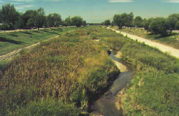
|
| Figure 1. Left
– Looking upstream at one of the vertical grade control structures. Right
– Looking downstream. |
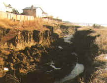
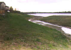
Cook Creek at Lone Tree Golf Course
When South Suburban Recreation and Park District bought this private course, Cook Creek,
which runs through the course, was suffering from severe degradation caused by urbanized
discharges and steep channel slopes (Figure 2). The project consists of several grouted
sloping boulder drop structures (GSB) placed to flatten the slope of the channel to arrest
the degradation. Now Cook Creek supports a wide variety of vegetation, and has swallowed a
great number of golf balls as well (Figure 3).
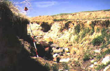 |
 |
Figure 2.
Cook Creek at Lone Tree Golf Course. |
Figure 3.
Cook Creek after construction of the grade control structures. |
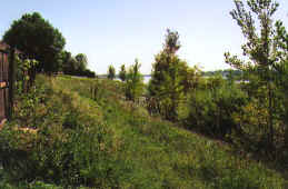
Jackrabbit Gulch at Union Ridge Park
This was a situation similar to Cook Creek. The solution was also similar although a
different hybrid drop structure design was employed. The project was completed in 1992
(Figure 4).
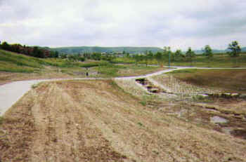 |
 |
Figure
4. After construction in June, 1992 |
Seven years later in
August, 1999 |
Cherry Creek through Denver upstream from University Boulevard
Grade control structures (wooden) were first built in the 1930’s. The District’s
Maintenance Program has been replacing the existing structures that have failed, and the
District’s Design and Construction Program, in cooperation with Denver, Glendale and
Arapahoe County, has been adding additional ones where needed over the last 10 years. The
replacement structures are GSB drop structures with design discharges in the 7,000 to
10,000 cfs range. Areas upstream from the original grade control structure locations are
heavily vegetated, while areas still unprotected by grade control structures have an
entirely different vegetative regime (Figure 5).
 |
 |
Figure
5. Left – Lush vegetation above a GSB drop structure on Cherry
Creek. Right – An entirely different regime in an area of Cherry
Creek not protected with a grade control structure. |
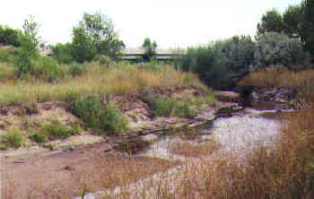
Hidden Lake Inlet Channel
Hidden Lake was drained and fill material excavated from the lake bottom in about 1990.
The lowered lake bottom and urbanized runoff resulted in severe erosion damage to the
inlet channel. The District’s Maintenance Program was called upon to correct the
problem by constructing a GSB drop structure at the downstream end of the inlet channel.
The channel is now overgrown to the point where some tree thinning may be necessary to
maintain the needed flood capacity (Figure 6).
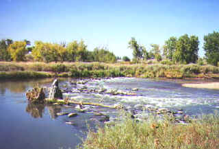 |
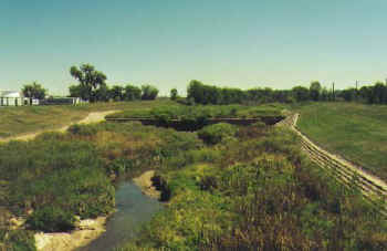
Figure 7. South Platte River
grade control structure. |
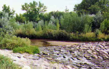
South Platte River
In addition to several major grade control structures, the District has installed a total
of 16 sloping, three-foot high, boulder grade control structures along the South Platte
River in Adams and Arapahoe Counties. The river bottom has been degrading over the years,
which has exacerbated bank undermining and erosion. The result was that much private and
public property and infrastructure (roads, utilities, etc.) was being damaged on a
continuous basis. Based on the recommendation in a master plan completed in 1995, the
District initiated an annual river survey program; and where more significant bottom
degradation was detected, grade control structures were installed (Figure 7). Observations
over a ten-year period reveal that the river bottom has virtually stopped degrading and
bank erosion has slowed. Each grade control structure covers the main channel of the
river, which has approximately a 10-year flood capacity of 10,000 cfs. Each is constructed
of one layer of three to four foot boulders on a graded rock foundation, sloped at a 10 to
12 percent grade, with the downstream end embedded into the river bottom at least five
feet. A boater and fish passage chute is provided in each, creating a relatively deep
scour hole downstream of the structure and adding to the aquatic habitat of the river.
Many of the structures have experienced 14,000 to 15,000 cfs flows without any evidence of
damage.
Summary
We know the effects urbanization will have on downstream channels and over the years we
have developed successful, field proven, designs to deal with those problems. One
unanticipated but welcome benefit has been the establishment of extensive amounts of
wetland and riparian vegetation along many ephemeral drainageways upstream of these grade
controls, vegetation that never existed before in our semi-arid region.
Acknowledgements